Maps are one of the most integral tools of the tourism industry. Be they digital or physical, big or small, printed or drawn, a visual reference is invaluable for directing and guiding people.
As part of my group’s efforts to bring the tools and techniques of the digital world to a physical medium, I have chosen to include maps on some mock up brochures in order to point prospective hypothetical visitors to the Vancouver area toward some of the landmarks I have chosen to highlight. While in person its simple enough to direct people to their mapping software of choice, most commonly Google or Apple Maps, in the format or a brochure the use of these maps is not as accessible due to concerns over copyright and whether or not a screenshot of a mapping software in print counts as reproduction.
To the more artistically inclined the solution may be to simply draw their own map for such a format, ensuring the rights to its usage by being the original creator themselves. But this will not always be a practical solution. However there exists a middle ground between original maps and existing digital maps.
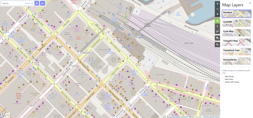
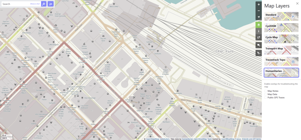
Open Street Map’s Standard Layer showing the area around Waterfront Station in Vancouver, BCOpen Street Map’s Transport Layer showing the area around Waterfront Station in Vancouver, BCOpen Street Map’s Humanitarian Layer showing the area around Waterfront Station in Vancouver, BC
Open Street Map is an open source mapping software usable on both mobile and desktop. Not only is this software community curated and likely to reflect recent changes in the map than software from a big company, but it is also reproducible, allowing the use of their maps in published works. Not only this but each region brings with it a number of optional “layers” that add or omit information based on differing needs such as the “Humanitarian” Layer which highlights public bathrooms and places to eat, or the “Transport” Layer which shows transit routes and information.
This open access and usage model, as well as the ability to tailor the information on the screen makes Open Street Map the perfect software to find and create visual references for use in print and online
Works Cited: Open Street Map: https://www.openstreetmap.org
Building off of my last inquiry, I once again took the time to put myself out in the field in an effort to gather materials for my group’s project. In our continued efforts to grapple with the tumultuous world of usage rights, we opted to each explore some of our local public display artwork. This we felt also paired well with the tourism angle we have been exploring.
For this, I suggested we find works that fit within 3 categories, those being indigenous, traditional, and contemporary art on display in BC. As I had already catalogued some indigenous art, I instead turned my attention to the the latter two categories.
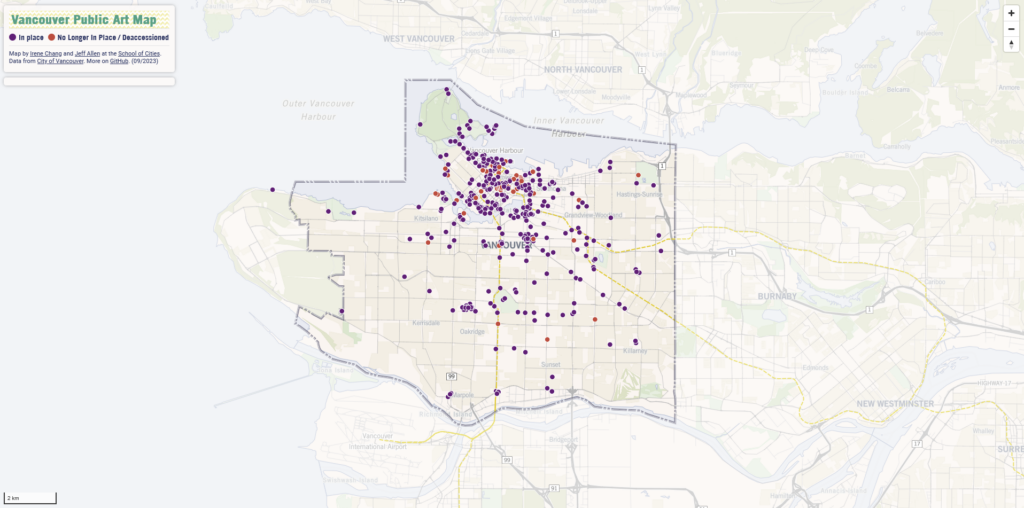
Luckily with some google searching I was able to find an online map that catalogues public art installations around Vancouver. As I was going to be downtown shortly after this decision was made, I used this to identify two pieces I wanted to highlight.
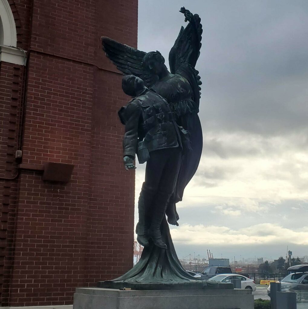
Angel of Victory Statue located outside Waterfront Station. Vancouver BC
For my traditional work I wanted to highlight a statue that I felt was emblematic of the artistic movements of 19th and 20th century colonial America. For this I chose the Angel of Victory, one of four identical bronze casts by Coeur de Lion McCarthy located at former CPR stations across Canada in commemoration of the First World War. For the sake of our project I wanted to highlight works such as this as pieces of historical significance, such as those commemorating victims of war are some of the most popular for older visitors and families.
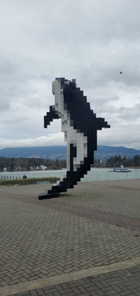
Douglas Coupland’s Digital Orca located just outside the Vancouver Convention Centre
On the other side of the coin, I wanted to highlight more contemporary works on display in Vancouver. For our purposes I wanted to highlight pieces that might not necessarily draw people to a location, but rather pieces that are emblematic of their city and which serve as something to find while exploring a new city. For this I chose Douglas Coupland’s Digital Orca sculpture which stands just outside the Vancouver Convention Centre. This imposing piece to me mates the natural beauty of British Columbia, with the modernity of the city of Vancouver, and serves as a perfect backdrop for photos, a meeting place with friends, or simply an interesting place to pass by.
Works Cited: The Importance of Sources: https://digitaltourism.opened.ca/2025/03/05/the-importance-of-sources/ Vancouver Public Art Map: https://schoolofcities.github.io/vancouver-public-art/map Digital Orca: https://covapp.vancouver.ca/PublicArtRegistry/ArtworkDetail.aspx?FromArtworkSearch=True&ArtworkId=521 Angel of Victory: https://heritagevancouver.org/top10-watch-list/2009/6-historic-monuments-angel-of-victory/
Continuing my rather unorthodox theme to this blog, I wanted to discuss the impacts of Generative AI on the tourism industry. As previously mentioned the topic of tourism, especially in British Columbia is one I have a lot of experience and knowledge in, and as such I wanted to bring that background in to this course in as many ways as possible in order to create a more interesting blog. For this week’s topic there is one particular angle I would like to approach when discussing the problems that can arise when using AI. That being how the production of materials can be used to mislead or otherwise misrepresent a given location.
Before we begin, I would also like to address that while I will try to approach this topic as neutrally as possible, I have a rather strong pre-existing bias against generative AI for artistic and practical reasons that I will not get in to at this time, and may colour how I represent or discuss it despite my efforts. Additionally as a disclaimer, for the sake of example there will be one instance of an AI generated photo in this post. This image was acquired using a simple google search and was not generated for by me or for the purposes of this post.
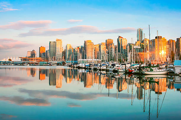
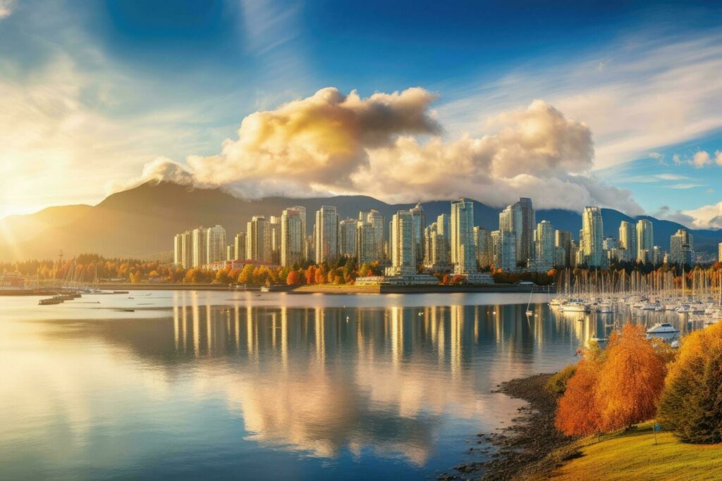
Two photos found via a google image search for “Vancouver Skyline”. Can you spot which one was generated by AI?
When discussing generative AI, the topic of AI art and image generation tends to be at the forefront. And I wanted to highlight something that has become increasingly common as a result. AI generated images in google searches. While in general I would argue prior to this the average google image search was never the best representation of a given location if one was looking for a place to visit or researching that city they heard about on TV. However recent advancements in AI and the proliferation of online publishing of these images has seen a rapidly growing number of such images presenting especially idealized depictions of popular destinations.
Above I presented two images side by side of the Vancouver Skyline as presented by googling that exact phrase and asked readers to guess which was generated by AI. To anyone familiar enough with common quirks of AI images, or the skyline of Vancouver, British Columbia the correct answer may have been obvious. The second image which appeared in an ordinary google search was in fact generated and posted by user Iftikhar Alam on Vecteezy. Conversely the first image which appeared in the same google search is instead a real photo of Vancouver’s waterfront and skyline taken by user bluejayphoto on iStockPhoto. But to one unversed in techniques to spot AI generated images, and/or someone unfamiliar with the location (such as a potential visitor researching the city) it is extremely easy to be misled.
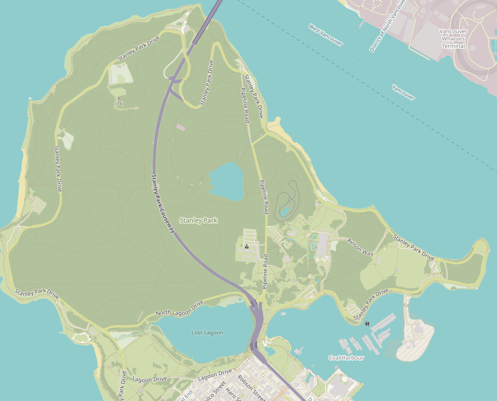
A screenshot of Stanley Park taken from OpenStreetMap. The above photo was likely taken somewhere along the edge of Coal Harbour at bottom right.
One such complication is the tendency for AI generated images to incorporate elements from multiple depictions of a location with little regard for the material reality. There are 3 key “landmarks” in the AI generated photo which commonly appear in photos of Vancouver but which cannot all appear in a single photo due to simple geography. These are the skyline of Downtown Vancouver itself, the sailboats moored off Stanley Park, and the North Shore Mountains. And you’ll notice in the real image, only the former two are visible. To put it simply, in order to get a photo with both the moored sailboats, and the Vancouver skyline in frame, a photographer must be facing at least partly south and thus having no way to get the mountains to the north in frame. And yet in the AI depiction, all three of these are clearly visible when this is simply an impossible perspective.
While ultimately the misplacement of landmarks in what is effectively a composite of thousands of existing photos of a location does not reflect poorly on a location, the potential to mislead prospective visitors is present. Not only that, but the prevalence of these images in simple searches that are likely to be seen by those looking up a location for the first time creates difficulty in creating accurate expectations for potential visitors. While to some it may be easy to spot these images at a glance, to those of us that work in the tourism industry, we cannot expect all our customers and clients to have the same skills and tools we have to spot these misleading or inaccurate depictions. The prevalence of AI generated material in search engine results creates an unnecessary burden on the user to discern fact from reality.
Works Cited: iStock Vancouver Skyline at Sunset by bluejayphoto: https://www.istockphoto.com/photo/vancouver-skyline-at-sunset-gm178388915-20368906 Vecteezy Vancouver Skyline AI by iftikharalam: https://www.vecteezy.com/photo/35758746-ai-generated-beautiful-cityscape-of-vancouver-at-sunset-british-columbia-canada-beautiful-view-of-downtown-vancouver-skyline-british-columbia-canada-ai-generated OpenStreetMap: https://www.openstreetmap.org